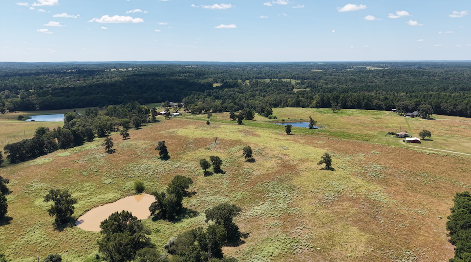
Rural Property Aerial Overview — Starting at $195
See your land and improvements from a perspective that simply isn't possible from the ground.
Our Rural Property Aerial Overview is ideal for farmers, ranchers, acreage owners, recreational property owners, and families who want a professional visual record of their property.
Includes:
12–20 professionally prepared aerial photographs
Overall aerial views of the property and acreage
Views from north, south, east, and west
Residence and major structures
Barns, shops, and equipment buildings
Ponds and water features
Pastures and open acreage
Driveways and major access points
High-resolution digital delivery
This service is designed for photography and property documentation rather than storm-related roof documentation.
Farms, Ranches & Rural Properties
See Your Property from a Better Perspective
Farms, ranches, and rural properties are often difficult to fully view from the ground. A single property may include a residence, barns, shops, equipment sheds, ponds, pastures, access roads, and other improvements spread across many acres.
Leon County Property Services provides professional aerial photography and drone documentation specifically for rural properties throughout Leon County and surrounding communities.
Whether you want professional aerial photographs of your land, need to document visible conditions following severe weather, or want both services completed during one visit, we provide a safe and efficient way to see your property from above.
Rural Storm & Structure Documentation — Starting at $225
Wind, hail, falling limbs, and severe weather can affect multiple structures across a rural property.
Our Storm & Structure Documentation service provides detailed aerial imagery of visible roof and exterior conditions without requiring the property owner to climb onto roofs or access difficult areas.
Includes:
Aerial documentation of multiple structures
High-resolution roof imagery
Multiple angles of visible roof surfaces
Close-up photographs of visible areas of concern
Barns, shops, sheds, and other outbuildings
Overall property imagery
Same-day photo delivery when practical
Simple condition summary
This service provides a clear visual record that property owners can retain and use when determining their next steps following severe weather.
Farms, Ranches & Rural
Complete Rural Property Package — Starting at $350
For property owners who want both comprehensive aerial property imagery and detailed storm/structure documentation, our Complete Rural Property Package combines both services during a single visit.
Includes:
Complete Rural Property Aerial Overview
Multiple aerial perspectives of the acreage
North, south, east, and west property views
Photography of major property features
Detailed aerial imagery of roofs and structures
Close-up photographs of visible areas of concern
Overall property photographs
20+ high-resolution digital images
Simple condition summary
Same-day delivery when practical
Purchasing the combined package provides both a professional aerial record of the property and more detailed documentation of visible roof and structural conditions.
Important Information
Leon County Property Services provides aerial photography and visual documentation services. Our services are not land surveys, boundary determinations, structural or engineering inspections, roofing inspections, or insurance coverage determinations. Any property boundaries shown or discussed are approximate unless supplied from an appropriate licensed survey source.
Starting at $350
Which Service Is Right for You?
Want professional photographs of your land and improvements?
Choose the Rural Property Aerial Overview — starting at $195.
Concerned about roofs or structures following wind, hail, or severe weather?
Choose Rural Storm & Structure Documentation — starting at $225.
Want both?
Choose the Complete Rural Property Package — starting at $350.
Pricing for Larger Properties
Every rural property is different. Properties involving extensive acreage, numerous structures, multiple flight locations, or additional flight time may require an individual quote.
Standard pricing includes travel within approximately 25 miles of Buffalo, Texas. Additional travel charges may apply outside our standard service area.
Why Choose Leon County Property Services?
Leon County Property Services is locally owned and operated by Byron Jefferson, a Marine Corps veteran, licensed insurance adjuster, and FAA Part 107 certified drone pilot.
We understand the unique characteristics of rural properties and the importance owners place on their land, homes, barns, and improvements.
Our goal is simple: provide clear, professional aerial imagery, dependable local service, and a perspective of your property that isn't possible from the ground.
Your Land. Your Improvements. A Better View.
Whether you own a few acres or a large rural property, Leon County Property Services can help you document and view your property from above.
Contact us to discuss your property, acreage, and structures and determine which service best fits your needs.